CNRS senior researcher. Data science, earth observation & environment
My main research focuses on the development of methodological approaches for the analysis of Earth observations (images, local sensors, time series, etc.). The applications are primarily related to environmental topics such as pollution, climatology, urban heat island, vegetation and agriculture.
I joined LETG-Rennes and OSE-Ren in 2004. Between 2009 and 2012, I was based in Beijing, China, where I worked for LIAMA (Laboratory of Informatics, Automatics, and Applied Mathematics), a joint lab comprising Chinese institutions: CASIA (Chinese Academy of Sciences, Institute of Automation), Tsinghua University, and European organizations (INRIA, CNRS, INRAE, CIRAD, Groupe des Ecoles Centrales).
Since October 2012, I have been back in France as a CNRS Director of Research with LETG. I lead projects in collaboration with both French and international research groups (including China, USA, Canada).
I develop and maintain rastereasy, a free and open-source Python library that makes it easy to work with georeferenced raster data.
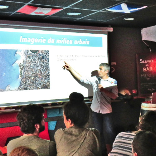
Feb, 2026 : we ( ANR-MONITREE , IRN ENVIRONET among others) co-organize the 1st national meeting on trees in cities! Check out the program here (feel free to register for free ! )
Multimodal Remote Sensing
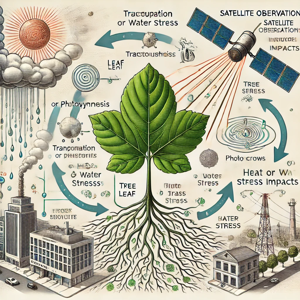
In the context of global change, urban areas face increasing challenges from extreme climate events. Trees play a crucial role in mitigating these impacts, but they must survive harsh environmental conditions. Our research aims to use physiological data, remote sensing, and machine learning to monitor tree health and develop management tools for urban resilience.
With Jean Nabucet, Cécile Sulmon-Maisonneuve, Gwenael Gouesbet, Nathalie Le Bris, Marion Chorin, Thierry Fontaine-Breton, Rémi Bodiguel, E. Le Rouzic, Karine Adeline, Laure Roupioz, Elise Collin, Etienne Everaere, Didier Le Thiec, Simon Berville, Dorine Desalme, Cyril Buré, Charlotte Pelletier, Sabine El Moualy, Xavier Le Bris.
cf ANR MONI-TREE (2024-2028) website
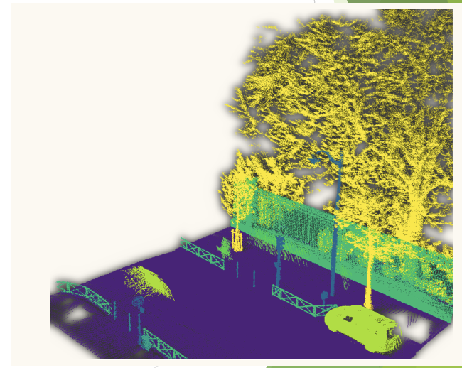
3D remote sensing
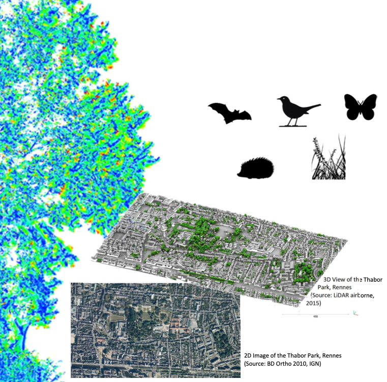
Use 3D LiDAR data to characterize urban landscapes, model functional connectivity, and identify ecologically functional greenways. By combining biodiversity data and LiDAR data, we seek to improve our understanding of how urban green infrastructure can support biodiversity and ecosystem services.
With Hei-Taïna Marais, Florent Guiotte, Solène Croci, Paul Leroy, Dimitri Lague
Remote sensing and physics
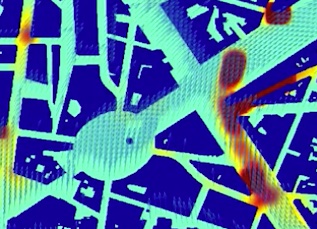
Coupling remote senging images, onsite sensors, physics and machine learning to understand and predict the evolution of urban pollution and heat islands.
With Hiba Hamdi, Laure Roupioz, Xavier Briottet, Jean Nabucet, Saho Liang, Stephanie Tumampos, Antoine Lefebvre
Machine Learning
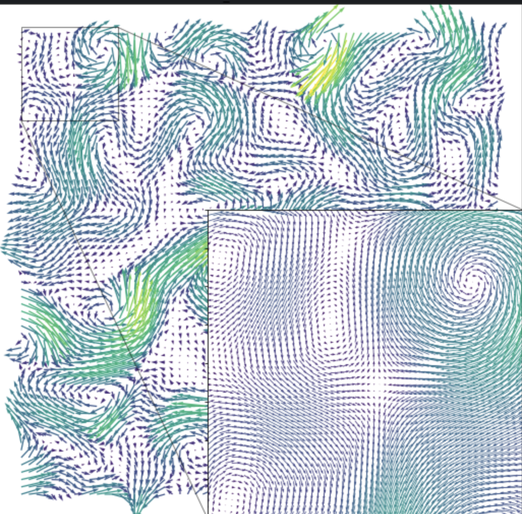
Analysis of links between Machine Learning, Physical Processes and Optimal transport.
With Diego di Carlo, Nicolas Courty, Dominique Heitz
Water turbidity
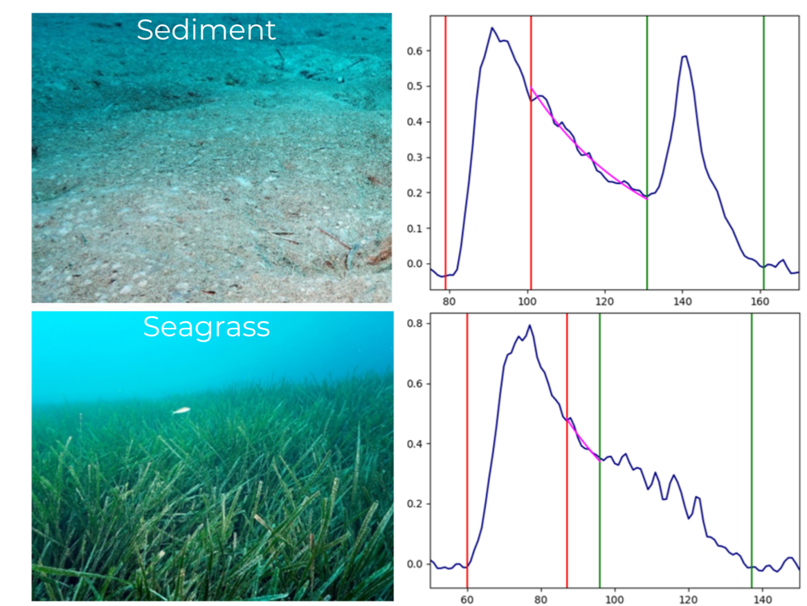
A bathymetric LiDAR is a remote sensing method that uses laser pulses to measure water depths. The resulting backscattered waveform contains valuable information related to turbidity, depth, and other parameters. Extracting these parameters from raw waveforms is a challenge, and we explore this aspect by combining physical models and machine learning.
With Mathilde Letard & Dimitri Lague
Health & Remote Sensing
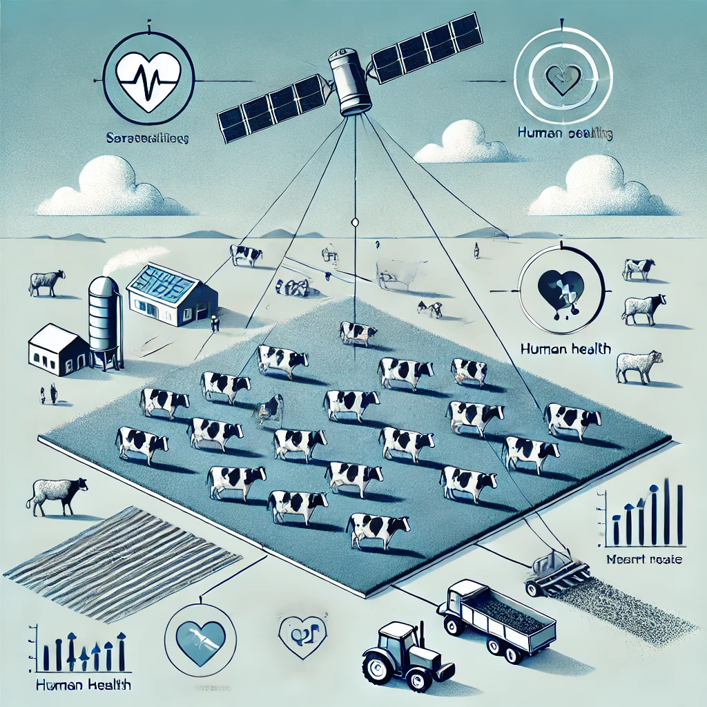
Assessing health risks associated with living near agricultural areas, particularly livestock farms. By leveraging Sentinel satellite data, we develop methods to identify agricultural practices, such as livestock buildings and fertilization areas, to better understand their impact on air quality and human health.
With Candide Lissak, Cécile Chevrier, Tarik Benmarhnia, Noemie Letellier, Nicolas Baghdadi, Sebastien Lefevre, Francois Merciol, Charlotte Pelletier
Object detection
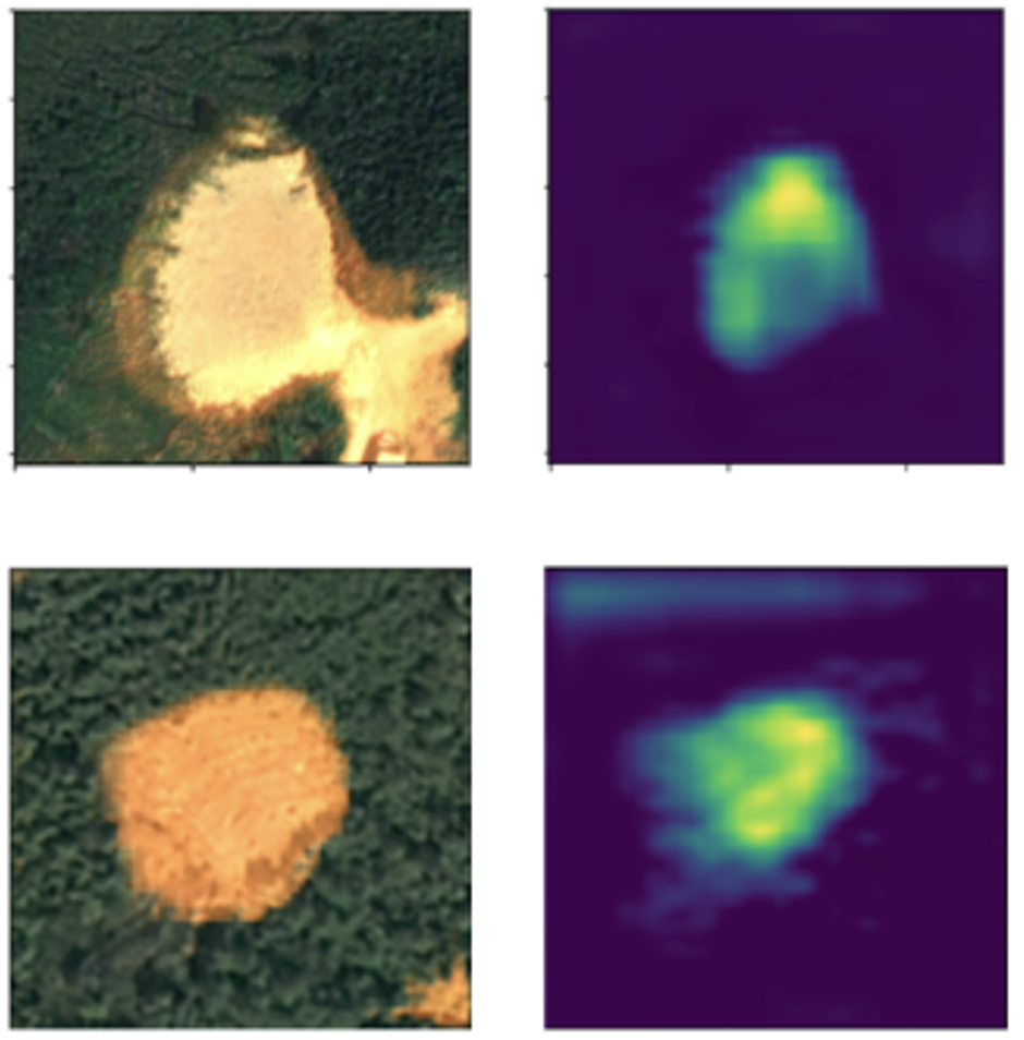
Neural network architectures for landslide detection using optical images and DEMs. Pre-training models on existing datasets and fine-tuning them with few new landslides data on new areas
Check out our open Hokkaido dataset in Japan
With Candide Lissak.
Super-resolution
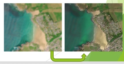
Neural networks for improving the spatial resolution of SENTINEL-2 and physical data (temperature, turbulence, vegetation).
With Aimi Okabayashi, Nicolas Courty, Charlotte Pelletier, Nicolas Audebert, Emilien Alvarez-Vanhard, Diego Di Carlo, Guglielmo Fernandez-Garcia, Charlotte Pelletier, Aurélie Michel, Carlos Granero-Belinchon, Antoine Lefebvre, Thomas Houet.
Point cloud analysis
Efficient processing and representation of 3D point clouds ; 3D change detection
Simulation of urban point clouds for machine learning
With Mathilde Letard, Iris de Gelis, Florent Guiotte, Sébastien Lefèvre, Dimitri Lague, Antoine Collin
Waveforms and time series
Semantic classification, structure identification, classification in waveforms
Comparison of time series, gap filling, analysis of historical data (change detection), transfer learning
With Mathilde Letard, Guglielmo Fernandez-Garcia, Dimitri Lague, Charlotte Pelletier, Ping Tang, Zheng Zhang, Antoine Lefebvre, Arnaud Le Bris, Antoine Collin
Remote Sensing
Different projects related to remote sensing in general (data fuion, links with ontologies, vegetation and agriculture monitoring, ...).
With Carl Bethuel, Damien Arvor, Samuel Corgne, Jean Nabucet, Laurence Hubert-Moy, ...

Administrative responsabilities
• In charge of LETG-Rennes since 2022
• Member of OSERen 's scientific council since 2023 and from 2012-2021
• Co-animation of MACLEAN (Machine learning for earth observation) action in GDR MADICS group since 2016
• In charge of sustainable development and international relations of UMR 6554 LETG
• In charge of the TIPE/CARIOCA research teams from 2010-2020
• Elected member of the scientific council of Univ. Rennes II since (2015 - 2023)
• In charge of the LOVE plateform (numerical aspects for environment) of OSERen from 2014-2022
• Scientific coordinator of LIAMA, 2011-2012
• In charge of of the "image analysis platform" of the Armorican Research Center in ENvironment (CAREN, 2006-2009)
• In charge of of the methodological axis of the Research Group MSG-ATR: Real Time Acquisition of Meteosat Second Generation data (2005-2009)
• Elected member of Social Sciences dpt's council, Univ. Rennes 2 (2013-2019)
Chair
• Co-organization of AI4EO, 2025
• Chair of 9ème colloque du Groupe Hyperspectral de la SFPT, 2024
• General Chair of Joint Urban Remote Sensing Event, JURSE 2019 with Sébastien Lefèvre
• Co-Chair of MACLEAN Workshop during European Conference on Machine Learning / Principles and Practice of Knowledge Discovery in Databases in 2019, 2020, 2021, 2022, 2023, 2024 and 2025 with Dino Ienco, Roberto Interdonato, Sebastien Lefèvre and Minh-Tan Pham
• Chair of TEMU 2020
• Co-Chair of 8 MACLEAN research workshops with Dino Ienco, Roberto Interdonato, Sebastien Lefèvre and Minh-Tan Pham and Sébastien Lefèvre
• Chair of 6 national research days in the conect of OSERen (time series, UAV for environment monitoring, LiDAR, ...)
Edition
• Associate Editor of Remote Sensing Journal
• Associate Editor of Earth Journal
• Associate Editor of Revue Française de Photogrammétrie et Télédétection, national journal
• In charge of Remote Sensing Special Issue Advances of Remote Sensing in Pasture Management with Pauline Dusseux and Laurence Hubert-Moy
• In charge of IEEE JSTARS Special Issue Paving the way for the future of Urban Remote Sensing with Sebastien Lefevre, Monika Kuffer, Hannes Taubenbock, Clement Mallet
• In charge of Machine Learning (springer) Special Issue Machine Learning for Earth Observation Data with Dino Ienco, Roberto Interdonato, Sebastien Lefevre, Minh-Tan Pham
• In charge of Remote Sensing Special Issue Machine Learning and Pattern Analysis in Hyperspectral Remote Sensing with Xavier Briottet
Reviews
Regular reviewer in many international journals as IEEE Transactions on Image Processing, IEEE Signal Processing Magazine, Journal of Photogrammetry and Remote Sensing, IEEE Transactions on Pattern Analysis and Machine Intelligence, IEEE Transactions on Geosciences and Remote Sensing, IEEE Journal of Selected Topics in Applied Earth Observations and Remote Sensing, Tellus Series A: Dynamic Meteorology and Oceanography, American Institute of Aeronautics and Astronotics, Image and Video Computing, International Journal of Mathematical Imaging and Vision, IEEE Transactions on Signal Processing, Experiments in Fluids, Electronic Letters on Computer Vision and Image Analysis, Measurement Science and Technology, Optical Engineering, Cahos, ...
Regular reviewer or PC member in many international/national conferences as ISPRS Congress, ISA, SSVM, FedCSIS, ISA, IEEE International Conference on Computer Vision, IEEE International Conference on Computer Vision and Pattern Recognition CVPR, IEEE International Conference on Robotics and Automation, IEEE International Geosciences and Remote Sensing Symposium IGARSS, IEEE International Conference on Image Processing, Asian Conference on Computer Vision, RFIAP, CAP, ORASIS, ...
Projects
•
• (Nat, PI) ANR MONI-TREE (2024-2028), MONItoring TREE comfort inside cities multiscale approach with multimodal remote sensing, physical modeling, deep learning and in-situ data
• (Int, PI) IRN ENVIRO-NET (2025-2030), Understanding and mitigating the impacts of environmental changes in territories with varying levels of human influence
• (Nat, PI) TOSCA SR4VEG (2024-2026), Super-resolution of SENTINEL-2 data for monitoring vegetation
• (Int, PI) France-China PIFI (2020-2024), Chinese Academy of Sciences President’s International Fellowship Initiative
• (Nat) Dynalearn (Cominlabs) (2020-2023), interactions between deep learning and physical models
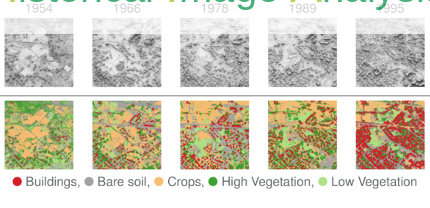
• (Nat) ANR HIATUS (2019-2024), Historical Image Analysis for Territory evolUtion Stories
• (Int) ANR MULTISCALE (2019-2023), MULTI-variate, -temporal, -resolution and -SourCe remote sensing image Analysis and LEarning, France and Turkey
• (Nat) ANR 6P, Interactions Plantes-Plantes Positives et Patrons spatiaux dans les résidus Post-mines Pyrénéens (2021-2024)
• (Int) ANR PALMEXPAND, Effets socioéconomiques et environnementaux de l'expansion des plantations de palmiers à huile en Indonésie
• (Int, PI) ISSI Residual, International Space Science Institute, Remote sensing image data assimilation for pollution monitoring: application to urban and ocean pollution, France, USA, China, Vien-Nam, Russia 2015-2019
• (Int, PI) France-China Deep-EO, Chinese Academy of Sciences - CNRS, Deep Learning for processing of earth observation data : application to local climate monitoring, 2017-2020
• (Int, PI) France-China Urba-Pol, Chinese Academy of Sciences - CNRS, Assimilation of multimodal observations for urban pollution forecasting and understanding, 2013-2016
• (Int, PI) France-China TIPE, Turbulence, Image, Physique, Environnement, LIAMA project, 2011-2014
• (Int, PI) France-China CARIOCA, Climate and Land Cover Analysis with complex data, 2014-2020
• (Nat, PI) CNES TOSCA VEGIDAR, Analyse de la Végétation en Ville par couplage LIDAR et PLEIADES, 2014-2017
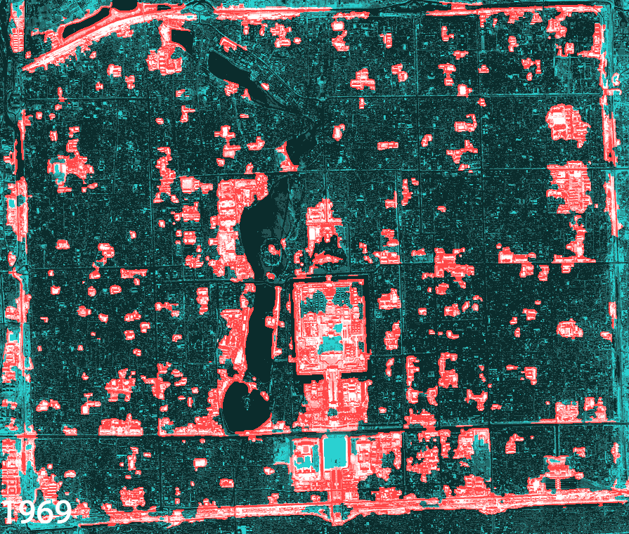
• (Nat) CNES TOSCA ARTIFICIALISATION, Suivi de l’artificialisation des sols par télédétection, soutien au CES (Centre d’Expertise Scientifique du pôle THEIA), 2015-2017
• (Nat) ANR ASTERIX, Analyse Spatio-temporelle pour la Télédétection de l’Environnement par Reconnaissance dans les Images compleXes, 2014-2017
Students & Post-docs
• Maxence Vandewynckele, co-supervised with Elise Colin, started in Jan. 2025. Prospective analysis of radar and optical signals sensitivity to characterize the functional status of urban trees.
• Augustin De La Brosse, co-supervised with Thomas Houet, started in may 2024. Multispectral and LiDAR for monitoring ecological systems
• Hei-Taïna Marais, co-supervised with Solène Croci, started in november 2024. LiDAR for biodiversity understanding in cities
• Aimi Okabayashi, co-supervised with Nicolas Courty, Charlotte Pelletier, Nicolas Audebert, started in may 2024. Super-resolution with focus on vegetation
• Hiba Hamdi (PhD CIFRE kermap, co-supervised with Laure Roupioz and Xavier Briottet, defended in Feb. 2025). Urban climate & neural networks
• Mathilde Letard (PhD, co-supervised with Dimitri Lague, defended in Dec. 2023). LiDAR data analysis (bi-spectral 3D point clouds, waveforms)
• Iris de Gelis (PhD, co-supervised with Sebastien Lefevre, defended in Apr. 2023). Change detection in 3D point clouds, Gdr MAGIS PhD Thesis Award
• Emilien Alvarez-Vanhard (PhD, co-supervised with Thomas Houet, defended in 2021). UAV and satellite synergies. Now in post-doc with IFREMER
• Florent Guiotte (PhD, co-supervised with Sebastien Lefevre, defended in 2021). Morphological analysis of 3D point clouds. Now research engineer in L'avion Jaune
• Sina Nakhostin (PhD, co-supervised with Nicolas Courty, defended in 2017). Hyperspectral unmixing. Now a post-doc with CNES
• Zheng Zhang (in China) (PhD, co-supervised with Tang Ping, defended in 2016). Time series analysis. Now has an academic position in Chinese Academy of Sciences
• Chen Xu (PhD, Ecole Centrale -Beijing, Lyon, defended in 2015). 3D turbulence analysis. Now has an academic position in Beihang University, Beijing, China
• Gong Xing (Phd, defended in 2015). Assimilation of remote sensing data in plant growth models. Now works in a company in China.
• Pascal Zille (Phd, defended in 2014). Fluid flow analysis in images. Now is a data scientist in Incepto Medical
• Pauline Dusseux (PhD, co-supervised with Laurence Hubert-Moy, COSTEL, Rennes, defended in Dec. 2014). Time series analysis for grassland monitoring. Now associate professor in Grenoble University
• Pierre Allain (PhD, co-supervised with Nicolas Courty, defended 2012, VALORIA, Vannes). Now is a data scientist in wipsea
• Antoine Lefebvre (PhD, co-supervised with Laurence Hubert-Moy, COSTEL, Rennes, defended in 2011). Creator and CEO of kermap
• Diego Di Carlo with Dynalearn project
• Guglielmo Fernandez-Garcia with ANR HIATUS project
• Claire Thomas with ANR MSG
Address
UMR 6554 LETG, Bâtiment N, Place du Recteur Henri Le Moal, 35043 RENNES CEDEX, FRANCE
Phone
+33 2 99 14 18 77
thomas.corpetti @ univ-rennes2.fr
thomas.corpetti @ cnrs.fr